
Using innovations in technology in creative ways is part of Argus Vision’s DNA. As photogrammetry hardly holds any secrets for this drone specialist, it is time to get to grips with other measurement and visualisation techniques, such as laser scanning based on SLAM technology – obviously in combination with the use of drones. This kind of application opens up promising perspectives for assignments in hardy accessible areas.
Over the last years, Argus Vision has unlocked the enormous potential of combining photogrammetry and drones. Listing an inventory of damage to buildings, stockpiling, mapping floods, measuring hard to reach areas, digital topography, detection of material use on façades… these are just a couple of examples of the products in the vast portfolio of Argus Vision. “The main advantage of photogrammetry is its high resolution, even to the point where details such as manhole covers, cracks in a wall or anchor points are easily recognisable”, explains co-owner Jonas Van de Winkel. “On the other hand however, the end results are less intricate. Typically, corners and edges of ‘measured’ structures become curved whereas slender features, such as lantern posts, overhead lines… are hard or even impossible to detect. Surfaces with little or no structure are also difficult to map, and vegetation is a major problem. If you require an in-detail terrain model of plots with dense vegetation, you will not get very far.”
Perfect tandem
Argus Vision has found a way to counterbalance these flaws of photogrammetry by combining it with surveying expertise. “The combination of our solution and terrestrial laser scanning mitigates the disadvantages of each technology when used on its own”, continues co-owner Seppe Koop.
“The laser scanners operate at the speed of light: 100,000 to 400,000 points per second is no exception, with a smaller than 1 mm accuracy within a 100-meter radius. However, the biggest setback is that multiple scanning positions are required in order to avoid shadows of objects in the foreground, so the laser scanner’s tripod has to be moved regularly. Of course, when sites are hard to access or in the case of large buildings in an urban environment, this can take up a lot of time or even be impossible. That’s where photogrammetry with drones is an excellent addition.”
How about ‘mobile’ laser scanners?
To help surveyors to work faster and more efficient, Argus Vision has been exploring the idea of airborne laser scanners. As such not a revolutionary concept, since this technology is being used on planes already. “This already is a widely used technique to build elevation models or large areas”, Jonas Van de Winkel points out.
“Because the laser scanner moves around, the position continuously needs to be corrected, which is done by linking the scanner to an IMU and GPS system. That way, non-stop calculations determine the correct orientation of the three axes and the position of the measurement apparatus. The coordinates of each measured point are adjusted, resulting in an accuracy level of 5 to 10 cm – insufficient for local measurements that require high resolution and accuracy levels. Moreover, the fact that deploying planes is a costly matter, makes it even less interesting.”
SLAM is starting to catch on
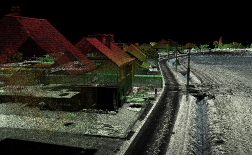
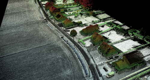
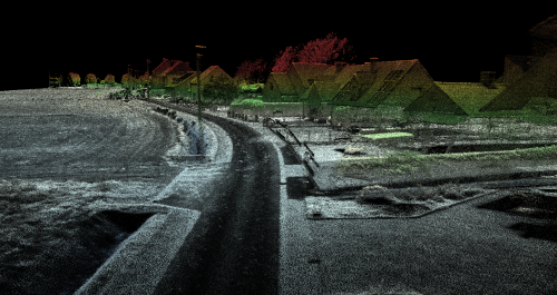
Connecting the laser scanner to a drone seemed the most logical solution for these kinds of surveying projects. “Initially, we tried to copy the technique of the planes”, tells Seppe Koop. “Unfortunately, most IMUs are too heavy for a drone, whereas the lighter versions proved to be too inaccurate; except for the SLAM technique we encountered just a little while ago. SLAM or ‘Simultaneous Locating And Mapping’ is based on an algorithm that continuously determines the new position of the laser scanner.” Jonas Van de Winkel explains: “The scanner measures up to 300,000 points per second. The algorithm each time compares which points match with the previous measurement. The overlap is then what the model is built from, step by step. Our first experiments show an accuracy level of 1 to 3 cm within a 100-meter radius.”
Unique service with a lot of added value
Indeed, Argus Vision invested in a special drone to test the SLAM scanner. Ibens Landmeters and Divatec became their partners in their quest to explore the possibilities of this technology. The results so far are very promising: “The measurement time is significantly shorter”, says Seppe Koop. “Almost inaccessible terrain or high buildings? No problem to create a perfect map with laser scanning. The 3 cm accuracy level does not yet compare to the result of static scanners, but it certainly can be used on plenty of occasions.” “We are extremely happy with our investment”, concludes Jonas Van de Winkel. “Photogrammetry and laser scanning both offer unique features. Photogrammetry results in a colour map of an unsurpassed resolution level. Laser scanning gives you a black-and-white point cloud with a superb level of accuracy. By blending both into one model, we can offer surveyors the best of both worlds. Our clients will receive top quality outcomes and the actual measurements take place in a very time and cost-efficient manner, while data crunching can be completely customised to requirements. Obviously, without ever losing sight of accuracy and finishing!”