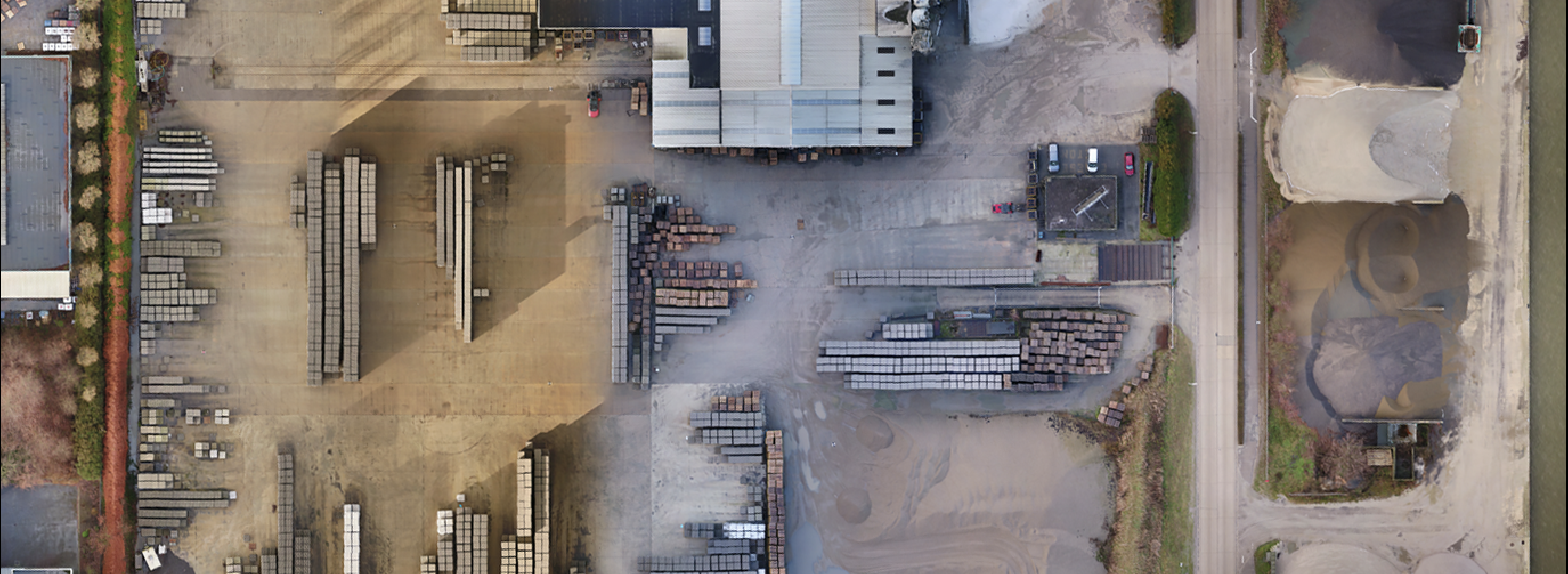
The combination of drones and photogrammetry paves new ways in the surveying industry. This innovative technology is especially interesting to define property boundaries and to draw up environmental plans. With the Claesen Beton case, located in Lummen, just recently Argus Vision demonstrated what can be done – much to the delight of surveyor Divatec and Élan Architecten.
Surveyors & drones: a great comboMapping large industrial sites isn’t always an easy task. Sometimes surveyors have to bridge huge distances to get everything measured, with shrubs and stocks of material more often than not stopping them in their tracks. Making a detailed visual of the adjacent terrains quite often is totally undoable.
Since Divatec is an innovation fan, they turned to drones and photogrammetry. Since then, this surveyor regularly calls in the services of Argus Vision. Especially when it comes to drawing up environmental maps, they seem to be the perfect duo.
Perfect project for drones
Some while ago Claesen Beton decided to build a new warehouse on its Lummen site. “In order to obtain a permit for this building, we first needed the site to be regularized”, states surveyor-expert Dieter Vandepoel of Divatec. “Some constructions on the terrain had indeed not been granted the correct permits yet. To this end, the architect needed an exact overview of the existing situation, a terrain of no less than 5.6 hectare.”

“Plenty of reason to call upon Argus Vision. We know from experience that drones in combination with photogrammetry are a very cost effective way for such projects. More even, the obstacles on the terrain would simply obstruct manual measurement. Concrete elements for instance have been stacked everywhere, sometimes even up to 6 meter high. At the back the boundary fence was hardy visible because it was overgrown with plants and weeds. So it was a fabulous example of how the use of drones and photogrammetry would make a difference, in the sense of speed, safety and accuracy.”
Collaboration for optimal result
Argus Vision by no means intends to take over the typical tasks of a surveyor. “We need each other to get an optimal result”, explains co-owner Jonas Van de Winkel. “Divatec for example benchmarked about 30 check points in this case, which we used to refine our rough point cloud. That way, we were able to map all areas requiring a 3 cm accuracy on the X and Y coordinates. Everything requiring a higher level of precision was measured up by the surveyor with a tachymeter.” Architect Lawrence Bessemans: “Like the contours of the existing building against which the new warehouse had to be built.”
Interested to discover all options, opportunities and limitations of drone use for surveyors?
Discover all ins and outs in this blog
How does this work?
After Divatec had marked the check points, Argus Vision used a drone to execute a first nadir flight over the site. “This is a grid-shaped flight”, tells co-owner Seppe Koop. “The camera on the drone took pictures in a 90° angle. We followed this by an oblique flight from all four compass directions, taking photos at a 60° angle, allowing us to also correctly model the vertical surfaces. In both instances we worked with an 85% overlap, which resulted in 2,500 images. A perfect amount to create an accurate point cloud. That cloud in turn became the basis of the orthophotos Divatec could start working from.”
Practical solution with extra benefits
Divatec blended the orthoimages with the results of the measurements by the tachymeter. “That way, we could still map all inaccessible areas”, continues Dieter Vandepoel. “In this example, the added value of Argus Vision was mainly practical, as the drones took pictures of areas we simply could not reach. Another great benefit is the fact that orthophotos immediately display all details, such as gutters or manhole covers. When traditional methods are applied, getting this level of detail might require a second site visit.”

Added value for surveyor and architect alike
The architect also is helped greatly by these orthophotos. “They supply the architect with a real overview of the site”, says Seppe Koop. “For example: in this case, 1 pixel represented 1 cm² of surface. This means the orthophoto is the perfect starting point for the design. What’s more, you can even upload the photos quite easily in SketchUp.”
Architect Lawrence Bessemans: “This was the first time we actually saw the possibilities of working with photogrammetry first-hand. In fact, the measurements were only required for the regularisation of the buildings on site, hence a 3D model was not needed. We used the plans supplied by Divatec to design the façade drawings in 2D. The orthophoto was a great aid to correctly draw the roofs on the implantation plan. That would otherwise have been difficult since the satellite photos available were not precise enough. We know we have not yet explored all advantages, but will do so in a next project for sure. Argus Vision most definitely made us curious about photogrammetry and drones!”
